This past summer my husband and I celebrated our 15th Anniversary by escaping to the wilderness country of Yosemite National Park for four nights and four days sans children. We hadn't backpacked since college and then I had only gone once and he had I think never gone. So we practiced hiked in Auburn and Pyramid Peak during the Winter and Spring of 2015. We poured over copies of the backpackers magazines and watched backpacking documentaries. We most importantly listened to elder stateswoman of backpacking, our friend Darlene, who with her late husband Steve cross country hiked most of peaks in California. They were intrepid adventures who could summit any peak and like to shun the trails. She even let us borrow most of their gear and was teary-eyed at seeing my husband done her husbands pack and poles. So this blog post is really in honor of Darlene and Steve and their many years of back country adventuring together.
When setting out to backpack in the Yosemite Wilderness it all starts with a Wilderness permit. We got the WRONG permit - Glacier Point to Illilouette Valley. To see how many permits have already been reserved ahead of time and any "open dates" left on certain routes you should head straight to this website.
Yosemite Trailhead Full Dates Report. Believe me I'm doing you a favor as this report is NOT easy to find.
Our main goal to hike from Glacier Point up the Merced River, through Merced Lake and Vogelsang High Sierra Camps (not using them as they are pricey, just camping near them) and finishing at Tuolumne Meadows (where we would get a wickedly yummy hamburger at the TM Grill). Yes, this was hiking uphill for about 31 miles. But it meant we got serious props from backpackers hiking the opposite (downhill) directions and avoided most of the crowds that seemed to hike the Sunrise High Sierra Camp route instead as this is on the John Muir Trail.
We found little information online about this route so we are relaying our experience for other backpackers who are hoping for me route information and answers to the questions: How can I hike past Little Yosemite Valley without getting caught by a ranger the first night? Will they catch me?
Here is what we learned! Step One: The day before you are set to hit the trail you can spend the night at backpackers camp down in Yosemite Valley. Just park say at Curry Village and hike in. Have your Wilderness Permit ready in case a ranger asks for it. If you get to the Valley way early the day before your permit starts, then head to the wilderness permit station and ask for a permit that better suits your needs. We were set to depart on the trail on June 28th with our permit that said Glacier Point to Illilouette Valley. The problem with this permit is that we would have to hike the Panoramic Trail and then dip South another mile at least in order to camp the first night and then we could only go to the Little Yosemite Valley or past there on our second night (hypothetically, but more on this later). We were going to try and hike right up to or past LYV and play dumb if a Ranger asked for our permit. Luckily we didn't do this AS even on the day of our departure we were able to score an awesome permit in person: Glacier Point to Little Yosemite Valley. This gave us the right to stay at Little Yosemite Valley on Night One, which sped up our progress significantly.
Cut to happy picture of my husband Nate getting a better wilderness permit just hours before we were set to depart on the trail with our old permit! This Summer Intern Ranger was happy for us. We got it at the Wawona Visitor Center as this is one of the place you can pick up your permits and I think even rent bear canisters.
 |
| Nate rejoices in a Little Yosemite Valley wilderness permit, unheard of the day of departure. |
Day One: We arrived Glacier Point at 10:20am and parked our car there. Be sure you roll up your windows all the way and get all food out of your car. We actually forgot one window and someone stole just our car shade AND our Yosemite entrance receipt (thankfully a ranger believed us on our way out of the park). We hiked the Panoramic Trail to Little Yosemite Valley that day one. We saw about 30 people on this hike until we got to Nevada Falls and the we say hundreds more people, most of which were getting stupid and swimming ABOVE the falls.
On the Panoramic Trail it was a bit hot for starting as late as we did. I recommend starting this hike in summer near 8am to avoid the heat especially on the switchbacks after Illilouette Falls. Some folks were even swimming above these falls as well, sliding down the cascade before the bridge.
 |
| View of Illilouette Falls from Panoramic Trail with Half Dome behind. |
Not far after a hot uphill past the Falls, we took the spur off the panoramic trail in order to see amazing views at panoramic point. Just follow a good trail book but DON'T take kids as it is a sheer drop off with NO railings.
 |
| The view from the edge of panoramic point. Upper Yosemite Fall all dry in late June! |
 |
| Me taking it all in. This view was amazing with endless grey and green. Half Dome in front of me. |
We continued past the turn second turn off to Illilouette Valley and got to see Half Dome again from the South side, amazing wildflowers and a view of the burn area that is Illiouette Valley. We were so glad we didn't have to follow our original permit and turn south at this junction for night one.
 |
| Southside of Half Dome during midday June 2015. |
 |
| Sign heading back the way we came, we've gone our first 4 miles. |
 |
| Turnoff south to Illilouette Valley through burn area. |
 |
| We are continuing at the turn off to head downhill now to Nevada Fall and then back uphill to Yosemite Valley. Merced Lake is our goal for Night Two. |
 |
| The lupines shift color throughout the park. These were are beautiful purple. |
The hike down to Nevada Fall from this point is shady and full of flowers and trees. At Nevada Fall we saw lots of people in the water above the falls and one guy sitting next to the mouth of the falls just one inch from the water, daring death. This situation was much like watching someone standing on the edge of a tall building almost about to commit suicide. However, since this was Yosemite park and a lovely waterfall noone said to him, "Dude, are you okay. You know life is worth living right?" It was an odd ethical dilemma for us and brought back social psychology questions from college back for me: Why do people participate in the bystander effect with someone's life is in danger?
At the top of the Falls we stopped and took it all in as best we could. In our journal my husband wrote: "Top of the Falls, adjacent to Liberty Cap, sun is out, bring fissures in granite into sharp relief. Top of Falls is so massive- a couple of lunatics near the roaring white water just seconds before it plummets over the precipice. No rain yet, sun is out, a bit muggy. Pines are growing out of the rock, as if eeking out a meager living. Passed a boyscout troop from So.Cal on the way here. Arrived at Left Fresno at 7:30am, started hike at Glacier Point at 11:15am, arrived Little Yosemite approx 4:45pm."
 |
| Perfect spot to chill away from the crowds and lay down that heavy Day One pack. |
 |
| View from top of Falls, Can see Glacier Point from whence we came. |
 |
| Peaking over the falls, I wouldn't bring my kids here, although my 8-year-old did hike here with his grandparents. Yipes. |
 |
| So the crazy guy was sitting right near this point but it was such a dangerous spot we couldn't even get his picture. |
 |
| Liberty Cap |
 |
| Resting the feet atop Nevada Falls. |
 |
| View of Glacier Point out starting point, as seen from Nevada Falls. Can you see the geology hut? |
 |
| An amazingly important rock under some granite, symbolizes motherhood I think. |
 |
| Sorry I can't get this video of the top of Nevada Falls to turn horizontal. But you get the idea. |
Continued to Little Yosemite Valley which was a bit hard to find our own place since got there so late in the day. The solar composting toilet was nice but it was a full moon so it was hard to sleep. Our stove broke and some guys helped us fix it. A father and son team who have been backpacking since his son, now age 22, was a little boy. We refilled our Camelbacks with filtered water from the Merced at Little Yosemite Valley.
For those of you trying to "get around the rules" of your permit here is the downlow. Some permits make you either stay away from Little Yosemite Valley Night One, or do the opposite and STAY at Little Yosemite Night One:
 |
| The Irish American Father/Son team who helped us fix our stove. We shared our Makers Mark hot coco with them. |
 |
| Filling our dromedary bags in the morning. |
 |
| Sunrise on Easter Face of Half Dome, so lovely the colors. |
 |
| Little Yosemite Horse Corral with solar composting toilet. |
 |
| Eastern Face of Half Dome at 8am on a summers morning. |
- No Rangers would have checked our permit if we had just continued up the trail towards Merced Lake and found a place to camp further up. No one was up there except for mule trains and the CCC. However, we couldn't really see a place to camp until maybe Burnell Cascade or Echo Valley, which are both quite a hike form Little Yosemite Valley.
- A summer intern did come and check ALL permits in Little Y. V. at dinner time. He would have sent us packing back to Illilouette Valley had we not gotten our changed permit that allowed us to stay in LYV night one.
- We didn't see another ranger until AFTER Merced Lake, which means you could likely hideout between LYV and Merced Lake Night one and get away with it.
- The Rangers we talked to had no argument for our other idea: what if you started hiking at 12:01am from Little Yosemite Valley. Isn't that the start of Day Two, which is when you are allowed to "hike past or through LYV?" both rangers said, "I guess you have a point there."
- After Night Two you can pretty much hike anywhere and, since some hikers can hike upwards of 15 miles a day, if a ranger catches you close to Merced Lake at the start of Day Two you can claim that you started hiking past LYV right at midnight which constituted Day Two!
- Also, there is another map that you can only buy in stores in Yosemite that has a purple shading to areas where you cannot backpack no matter what your permit says. This map is not online anywhere and was only shown to us by the intern at the Wawona Visitor Center. Sorry, we didn't buy it at that time. But it did show us how far we would have had to hike down the Illilouette trail on Night One if we wanted to actually follow the rules. It wasn't all the way to Illilouette Valley as we were told on the phone.
Day Two: At 5:30am the birds of Little Yosemite wake everyone up with all their bird calls. It was crazy loud. Even so, we got started too late (9am) which led us to hike through the burn area under very hot conditions. This fire occurred in September 2014 and several backpackers we talked said it wasn't even worth hiking this way. But after two miles the burn area was done and we had endless miles ahead of us without burn damage.
Little Yosemite Fire of Sept. 2014
 |
| Two miles of severe burn, very hot at 9am, not shade, no where to camp. |
 |
| Two mule trains of five mules each. Time to get off the trail. Howdy ladies (all these mule trains seemed to be led by women in their 20s)! Go Cowgirls! |
 |
| Dusty after the mule train comes by. |
 |
| Some green starting come back to Little Yosemite Valley near the eastern edge as the Merced gets closer. Could maybe camp in here but it would be illegal as it isn't past Morriane Dome yet. |
 |
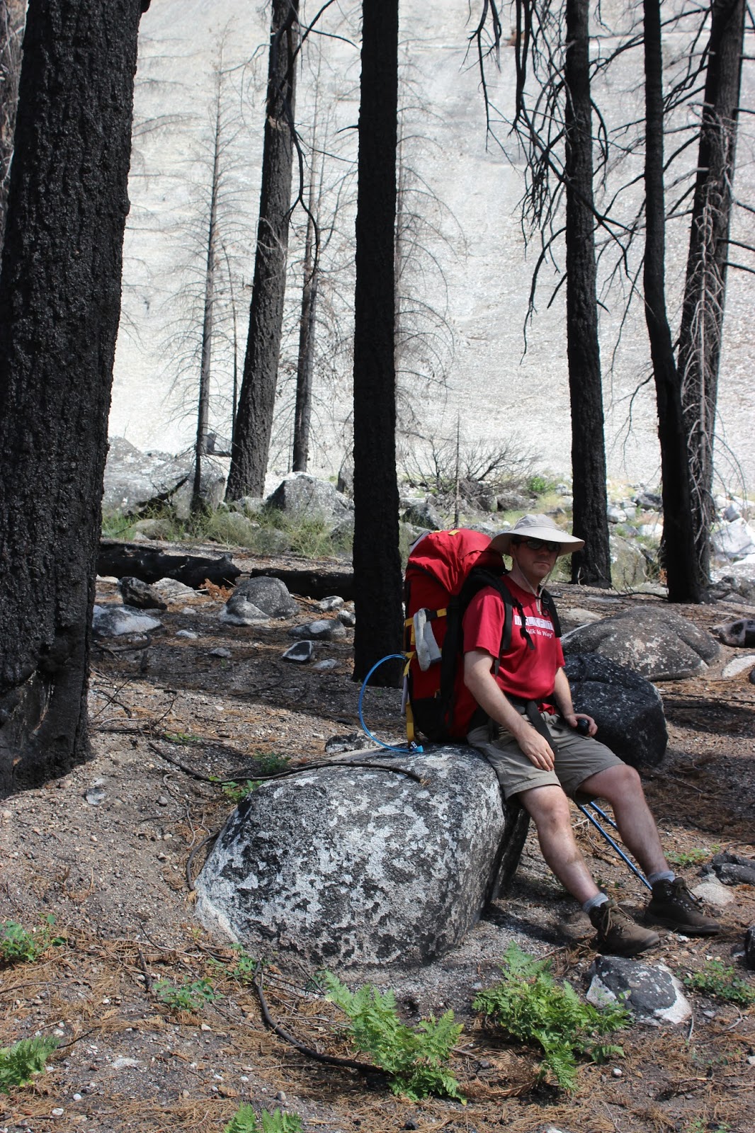
| A hot hike this summer day and seriously dusty. But hiking through a burn area gives you solitude and a clearer view of the granite all around. This is Nate resting his feet. |
It was 100 degrees in the Yosemite Valley this day so we were hiking in likely the high 80s. We saw mule trains and CCC workers this day and only perhaps 5 backpackers. Many of the backpackers were workers at the High Sierra Camps hiking into their first day at work. Most of these High Sierra Camps open around July 1st. This was about a 9 mile day and really wore our beginner legs out. But it was so beautiful!

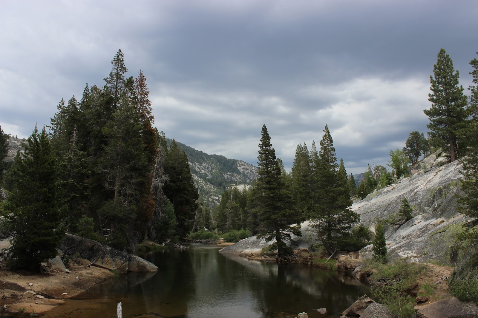
You then descend a bit through a very beautiful spring-fed wildflower area (lots of mosquitos though). You cross the Merced a second time and then hike through first, Echo Valley (which echoed with thunderclouds) and amazing granite slab area (with trees growing through the rock). Then you head right past Merced Lake to the backpacking camp.
 |
| Second Bridge Crossing over the Merced, close to the trail junction to Sunrise Camp, which we ignored and stayed to the right to continue to Merced Lake. |
Several hikers asked us on our way into Merced Lake where they should camp if they were hiking back to Little Yosemite. We would love to have stopped and spent a night in Echo Valley. It was lovely but we hardly even took pictures as thunder clouds were threatening. Our mentor, Darlene, agrees that Echo Valley is a lovely spot to pitch a tent for a night and is hardly ever visited because most folks go up the Sunrise Lakes route. Note to self and other parents: While Echo Valley would be a lovely camping space to get there you have to cross a portion from Merced Lake that has some sheer drop offs into the cascading Merced. This is exposed granite and due to threatening clouds we were not able to take pictures of the stunning sequoias that were stunted and growing from the granite near these cascades. Merced Lake is surrounded by Black-eyed susan flowers and is very calm; it makes you wish you could camp near it but there are a lot of signs that say "no camping." High Sierra Camps water and toilets were not open yet on June 30th and promised to open by July 2nd, after we were gone!
 |
| Run off at the bottom of the cascade near Merced High Sierra Camp, where people filter water. The potable water was NOT available as posted on July 1st or 2nd. The Ranger we saw said we could have used his potable water at his cabin. But we didn't know that. You can see the threat of thunder and lightening above us the morning of Day Three. |
 |
| Our remote backpacking site with fire pit, everyone backpacking spot we saw had a pre-made fire pit. There are bear bins for the backpackers to share, which is helpful since we still had so much food and other smelly medicines. |
Day Three: Hiking the hard route up Vogelsang Pass to Vogelsang High Sierra Camp from Merced Lake. Approximate distance 7 miles. We met a Ranger (a real one this time) who asked for our permit and let us know we could have used his potable water at this cabin (since High Sierra Camp was behind on getting theirs turned on). Instead we had spent the morning trying to fix our broken stove and filtering water.
Our legs were very sore and our spirits a bit low. But we knew that had to go the pretty/hard route to Vogelsang in order to see the prettiest views of the park (according to our interviews of many elder statesmen of backpacking).


 |
| Heading up the pass. |
 |
| First views of the higher Glacier peaks of the park. Like Amelia Earnhardt and Mount Lyell. |
 |
| A glacial erratic - a rock left behind by a powerful glacier. |
 |
| After the one mile steep climb we are at the pass with Mount Vogelsang above us. |
 |
| Views from the pass don't really due it justice, halfway down the mountain you can see one of the many alpine lakes. |
 |
| Turning slightly to the left from the previous picture, you see this. |
 |
| Us at the windy pass. This photo was taken by a timer. |
 |
| The path forward, with Sarah walking ahead. |
 |
| Endless beauty in every direction. |
 |
| Granite and then glacier-holding peaks. |
 |
| As turn around the backside of the Pass the wind suddenly stops and you enter this silent hamlet with an unnamed pond. |
 |
| Stunningly clear and silent pond at the top of the world. |
 |
| I wish we could stay here forever but the thunder clouds are threatening. |
 |
| Looking down at a marmot who is keeping watch over Vogelsang Lake. High Sierra Camp can be seen at the far edge of the lake. |
 |
| Stunning flowers crop out of moss covered rocks. |
 |
| Bright green grasses rely on afternoon storms. |
 |
| Sarah trying to descent before the storm hits. |
 |
| Looking north to Toloumne Meadows. The peak to the left could be Joanna Peak. |
 |
| Path down to camp. |
 |
| Nate looking back from where we came. It is so far from Half Dome we can hardly see it. |
 |
| Fletcher Peak just before the rain burst. |
 |
| Fletcher Peak right before the rainstorm gushed for 30 minutes at about 6pm. Our best shot of the trip. |
A 1/4 before camp it started raining hard so we took shelter for a 1/2 hour under the overhand to the toilets at High Sierra Camp. No one was around here but luckily we met some trail angels at backpackers camp who let us use their Jet Boils to make a hot meals that night and through to Day Four! Overall Nate's hips are sore and bruised and I had a bad head cold by this point. However, today the first 4 miles were just hard, and so were the last 2-3 but they were what made it all worth whiled. This entire hike was about the last 3 miles of this days hike. Simply breath-taking and life-changing beauty.
Day Four:
We stayed an entire day at the Vogelsang backpackers camp and bought some candy and lemonade from the High Sierra Camp store. We hiked down to Boothe Lake on a day hike and just rested our blistered feet and met numerous trail angels who shared their whiskey, jetboils, advice, and backpacking stories with us (I mean how could we leave with that kind of hospitality).
 |
| Panoramic shot taken on a Iphone of backpacker camp. On the right in the dark portion you can sort of see the bearboxes for backpackers, the out of comission solar toilet building is the center. High Sierra camp is to the left of that in front of Vogelsang peak, and Fletcher peak and lake are on the far left. |
 |
| There is a small historical library in the High Sierra Camp mess tent/store. |
 |
| Boothe Lake is amazingly beautiful and full of mosquitos. We only stayed there a few minutes. |
 |
| The shelves behind this guy are the "store." They only had one pack of m&Ms. But he gave me some blister treatment for free. |
 |
| Storm blew in fast to cover Fletcher Peak. We Jetboiled dinner and had to dive into our tent with food to avoid the storm. |
 |
| Chalkboard inside the High Sierra Camp mess tent. Good message. |
 |
| Booth Lake before the storm. Can you see the fire flowers on the grass. |
Day Five: The hike down from Vogelsang to Toloumne Meadows. Six miles or so in less than 3 hours. It was so easy hiking downhill after a day of rest and three days prior of hiking up hill. Sleeping two nights at over 10,000 feet also helped us feel strong on this final descent. The meadows down Rafferty Creek were pretty but nothing like Vogelsang Pass and camp.
 |
| Well-deserved lunch, picture taken on a very dirty Iphone. |
We loved our epic adventure and learned many things (some we can share and some perhaps not) but here are our top five:
- have a backup plan for if your stove breaks
- make new friends up there that are as crazy as you are
- don't overpack heavy food but pack raingear
- Maker's Mark is a good companion
- don't be afraid to ask other backpackers for help or advice
- getting away from it all is really necessary and restorative
- expect Rangers to be few and far between and thus somewhat avoidable until you need them and then you are desperate for a Ranger Station.
- bring Deet and moleskin
- expect to be astounded by beauty
- bring a pencil/paper, cards, or something to read
Cheers! And happy backpacking all!!!!


 And what a feeling when we rounded the last corner tot he pass - the highest elevation we would reach. A Tiny pond at the pass then on, the other side , we look down to Vogelsang Lake and the High Sierra Camp. We are headed downhill now as the thunderclouds fly over Fletcher Peak and frown at us. The lake is gorgeous and was we come around and down tot he camp we see Emeric Creek Valley and Half-Dome to the left.